
|
|
|
|
|
|
|
|
|
|
|
|
|
|
|
|
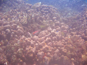
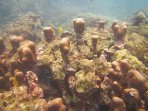
This page highlights some of the most evident issue of marine environmental degradation in Dominica. Those who wish to get involved in reversing some of the negative trends, may find useful starting points herein. Please note that the latest environmental changes have not necessarily been incorporated in the 2008 pages on regions, habitats, and species. Refer to main ITME reports page for the most recent accounts. Status of Marine Habitats 2016 Status of Marine Habitats 2013 Status of Marine Habitats 2008 Status of Marine Habitats 2007 Status of Marine Habitats 2016 Tropical Storm Erika (August 2015) devastated several parts of Dominica, causing many environmental scars, as well as the loss of human life and the destruction of key infrastructures such as roads and bridges. Coastal marine habitats were primarily influenced by high inputs of fresh water, terrestrial sediment and debris. During visit to the reefs near Mero and Salisbury, in September 2016 a few observations could be made, which are shared hereafter. CORAL REEFS Small reefs within 100 m from shore, such as the Macouchery Reef, were completely buried by sediment during the aforementioned storm event, (pers. comm. H. Zahn). Based on similar observations from 2003 - 2005 near Fond Colé, the skeletal remains of previously live corals will eventually reappear as sediments get washed away during the prevailing natural current and wave regimes. However, full resettlement of the site by coral larvae that successfully grow into colonies will take many decades. The large oligospecific coral assemblages at Mero, which are dominated by Madracis auretenra (Weil & Coates, 2007) mentioned as Madracis mirabilis throughout this site, appeared rather unharmed by the large sediment loads that they had been exposed to in August 2015. As these structures are among the largest living coral reefs of Dominica, this is an encouraging observation.The particular ramous architecture of the colonies and the banks that have formed over centuries, allow for the trapping of sediments and the continued growth of the entire reef. Another positive development was evident at Salisbury (Lauro Reef). Massive frameworks of Orbicella annularis (Ellis & Solander, 1786), mentioned as Montastraea annularis throughout this site, which experienced steady loss of live tissue between 1999 and 2013, showed small signs of recovery in 2016, in that remaining tissues appeared to be expanding laterally with few signs of corallivory |
||||
|
||||
If such observations can be made in other parts Dominica, a minimal (albeit very slow) recovery of this species in Dominica may be possible. Orbicella annularis is among the most important components of framework building stony corals in Dominica's. Its continuous loss of live cover throughout the island, had been pointing at a collapse of the these structural components. SEAGRASSES The invasive seagrass Halophila stipulacea, appears to persist as dominant seagrass along the west coast, where its explosive expansion between 2007 and 2012 had replaced all native seagrass meadows. I did not have a chance to see whether the remaining native strongholds of Syringodium filiforme still existed and whether H. stipulacea had penetrated the north coast, which it hadn't up to 2013. Compared to previous visits, juvenile fishes were much more common within the invasive seagrasses and there was an abundance of a dark brown, branching sponge (Haliclona sp. ?) on H. stipulacea that I had not seen before in Dominica. OTHER Earlier this year, Kramer et al. (2016) published Dominica’s Coral Reef Report Card 2016. A substantial amount of information used to create the document was derived from this site and the studies made by students and staff of ITME (see www.itme.org/reports). Hopefully, the Coral Reef Report Card will help in reaching a wider audience and in facilitating a better understanding of the scale of Dominica´s coastal marine habitats and the chronic impacts to which they are exposed.(see also Steiner 2015). REFERENCES Kramer PR, Roth LM, Constantine S, Knowles J, Cross L, Steiner S (2016). Dominica’s Coral Reef Report Card 2016. The Nature Conservancy. Steiner SCC (2015) Coral Reefs of Dominica (Lesser Antilles). Ann. Naturhist. Mus. Wien, B, 177:47-119. SCC Steiner, 09.2016 Please cite: Steiner, SCC (2016) Marine Habitats of Dominica: Status update 2016. (http:www.itme.org/mhdm/status.htm), viewed dd-mm-yyyy.
Status
of Marine Habitats 2013 The underwater landscape along Dominica's near shore marine environments continues to change rapidly. CORAL REEFS Live coral cover continues to decline. Even those reefs that were among the healthiest in terms of (a) their live coral cover (15-20%) and species richness, (b) the presence of large living coral frameworks, and (c) a diverse array of reef fishes and invertebrates, up to 2008 (e.g. Grande Savane and Mero) have deteriorated at a pace unprecedented since our first records from 1999. Coupled with the multiple chronic stressors described in earlier status descriptions from 2007 and 2008 (below), coral bleaching in 2010 further expedited this degradation. Virtually all previously remaining coral frameworks that still harbored considerable live coral cover are now skeletal ruins overgrown by algae. At a time when a the first detailed island-encompassing documentation of Dominica's coral reefs has been completed, the outlook on the survival of the few remaining coral reef communities is disheartening like never before.The forthcoming paper Coral Reefs of Dominica, by SCC Steiner, provides a detailed look at the current status.Abstract Systematic investigations on corals reefs of Dominica began in 1999 with the establishment of the Institute for Tropical Marine Ecology on the island. Taking into account the geological and oceanographically traits of this volcanic island, and its history of marine investigation, this report summarizes data on the distribution and morphology of reefs and coral assemblages, based on studies carried out between 1999 and 2013. It is the island-encompassing account, describing 31 coral reefs and 27 coral assemblages, including 46 species of stony corals (Scelarctinia, Anthozoa) and 4 species of hydrocorals (Anthoathecata, Hydrozoa). The present condition of Dominica's reefs is discussed in view of historic resource uses and the current exposure to sediment inputs, solid waste, effluents, fisheries and tourism. Perpetuated misconceptions on the location and size of the island's reefs are depicted and guidelines for their preservation are outlined. SEAGRASSES The most drastic change in the underwater landscape has been induced by the explosive expansion of Halophila stipulacea which replaces most native seagrass meadows and caused a cascade of changes in Dominica's western sublittoral.The forthcoming paper The expansion of Halophila stipulacea (Hydrocharitaceae, Angiospermae) is changing the seagrass landscape in the Commonwealth of Dominica, Lesser Antilles, by SCC Steiner and DA Willette, provides a comprehensive account of the recent changes. Abstract The seagrass Halophila stipulacea, alien to the Caribbean, was first reported from Dominica in 2007, where its rapid growth and ability to supplant native species, as well as the profiles of native seagrasses meadows were established in 2008. In 2013 we reexamined 27 meadows and observed a highly altered underwater landscape along Dominica's west coast (leeward) and unchanged seagrass beds along the northeast (windward). On the western sublittoral, pure stands of H. stipulacea replaced most Syringodium filiforme meadows and Halodule wrightii in depths greater than 4 m, as well as all Halophila decipiens stands and meadows. Fauna and flora occurring within seagrasses was concentrated in the remaining native seagrass stands. We identified three scenarios of increasing impact by H. stipulacea; "native strongholds" of pure native stands, "invasive takeovers" where native seagrasses were completely replaced, and "new meadows" in areas previously free of seagrasses. The area covered by Dominica's seagrasses doubled from an estimated 316 ha in 2008 to 773 ha in 2013; driven exclusively by the spread of the alien seagrass. Benefits and losses of the recent angiosperm invasion are unforeseeable, yet the remaining strongholds and the unchanged north coast meadows, point at ecological limitations in the invasibility of native seagrasses and environmental circumstances that foster refugia for some native species. However, based on the increasing number of sightings H. stipulacea in the Lesser Antilles, we predict large-scale alterations in the architecture and species composition of seagrass meadows throughout the Caribbean within the next decade, and the demise of H. decipiens.See our main reports page for details. www.itme.org/reports.htm SCCS0613 Please cite: Steiner, SCC (2013) Marine Habitats of Dominica: Status update 2013. (http:www.itme.org/mhdm/status.htm), viewed dd-mm-yyyy. (Jan 2015 UPDATE 1: New paper on coral reefs of Dominica Also see our main reports page for related papers. www.itme.org/reports.htm.) (Jan 2015 UPDATE 2: New paper on invasive seagrass in Dominica. See our main reports page for new papers. www.itme.org/reports.htm) Status of Marine Habitats 2008 Over the past year, the analysis of the data collected during ITME's 2007 large-scale habitat survey has revealed interesting new perspectives on Dominica's marine resources. The single largest surprise was the extent of seagrass beds in Dominica. We now know that these are the largest marine habitats in Dominica created by organisms. With ca. 266 ha+, their cover far surpasses that of coral reefs. Furthermore, the new results largely contradict the few governmental and non-governmental reports mentioning the distribution of marine habitats, which appear to not have been based on field surveys. Most studies on Dominica's benthic communities up to 2007 focused on coral reefs and assemblages. Only 8.6 ha of reef surveyed last year had previously not been recorded. It has been clear that coral reefs are marginal communities on the narrow shelf of Dominica, but just how marginal is now apparent considering that they only cover approximately 81 ha. This finding does not support non-governmental reports listing 700 ha of coral reefs in Dominica. Even when considering coral assemblages found in some of Dominica's rocky environments, characterized by a lack of reef accretion as "coral reefs", the benthic cover would be far below 700ha. The concrete figures now available for the distribution and dimensions of Dominica's marine resources provide a key reference point for future and past studies. Given the extensive distribution of seagrasses, new studies were launched in 2008, focusing on the horizontal zonation patterns in local seagrass beds. These on-going studies which include the deeper seagrass beds not surveyed in 2007, are providing additional insights into the distribution and benthic cover of the five so far identified seagrass species (see organism lists). Furthermore, it has become clear that the distribution of invasive H. stipulacea (as initially reported by D. Willette), is far more extensive than anticipated. The most recent studies, revisiting existing species inventories, fell within the impact of Hurricane Omar. Although not directly affecting Dominica, its south-eastern windbands led to strong surge along the west coast, causing coastal erosion and flooding. In rocky habitats, large numbers of sessile invertebrates and algae were uprooted. In sandy environments, extensive shifts in sand were noticed. Seagrass beds in some cases (narrow shelf) disappeared completely due to a combination of burial and erosion. Anthropogenic debris and lost fishing gear (gill nets, boats, pots, engines) also caused considerable damage to reefs. In particular large nets became death traps for many invertebrates, fishes and turtles. Given this strong disturbance, recent findings on the distribution and abundance of selected organism groups were rather conservative. This event, however, highlights the impact of natural disturbances in narrow shelf settings, and how this has shaped the distribution of marine habitat types in Dominica. It also serves as a reminder that the mitigation of local human-induced and enhanced disturbances remains a key element in any attempt to slow down or stop the degradation of Dominica's near-shore marine resources. Currently, sediment input increased via coastal construction and dumping, solid waste (degradable and non-degradable) and fishing pressure are the negative local disturbances apparent to anyone who spends some time exploring Dominica's coastal waters. SCCS1108 Please cite: Steiner, SCC (2008) Marine Habitats of Dominica: Status update 2008. (http:www.itme.org/mhdm/status.htm), viewed dd-mm-yyyy. Status of Marine Habitats 2007 Human activity along Dominica's shores can be traced back several thousand years, but the heaviest uses are likely to have started in the mid 1700s with the first concerted settlement attempts by the French and British. See the writings by Dr. Lennox Honychurch for further historical information at www.lennoxhonychurch.com The steep terrain of this young volcanic island (with its recent volcanic formations occurring less than 1.8 million years ago) is evident in its narrow shelf area and rugged interior. Settlements have historically sought the coastal zones and in particular the valleys opening to the sea. Valleys offer the best arable land, easy access to inland areas and water which became an important source of energy for the mills of Dominica's estates. This scenario has put marine life and habitats in close proximity with population centers. Herein lie the main sources of marine environmental degradation. Sediment runoff from land, a natural process, is exacerbated by activities such as deforestation for agriculture, logging and other activities and purposes. In essence, any activity that decreases the sediment retention (for example via vegetation) of a particular area leads to increased terrestrial runoff. Increased sedimentation due to infrastructural development and sand/gravel quarrying are among the recent sources of this type of disturbance. The negative impacts of this process include the suffocation of marine organisms, weakening of animals allocating excessive energy to rid themselves of sediment, and decreased light levels affecting photosynthetic organisms. The consequences can bee seen in the burial and consequent death of coral assemblages (Fond Cole) and sea grass habitats (West Coast). But coastal zone degradation comes in many forms. The most evident is the illegal and legal dumping of building materials, as well as industrial and household refuse. Unfortunately, evidence of this activity is commonly seen throughout the island. Once submerged in the sea, these materials are out of sight and out of mind for some, but strong storms and hurricanes occasionally spit these materials back onto allowing for reconsideration of this practice. When humans add materials into the sea, and the concentration of these "additions" exceeds the natural background levels, we speak of contamination. When contamination leads to the degradation of marine habitats and or human health, as well as human interests in marine resources, pollution is the term used by international conventions. Measurements of marine pollution in Dominica have not been carried out to date. Signs of contamination, however, are evident in the vicinity of population centers. The clearest signs come in the form of household and industrial waste and debris, which physically damages habitats and sessile organisms, and increased algal cover. Other forms of degradation arise from the extraction or harvesting of marine life. Both the extraction techniques applied and the biomass removed can lead to the collapse of individual species or lead to phase shifts within entire ecosystems. The narrow sublittoral zone of Dominica represents a limited resource. Therefore, the multitude of fishing techniques (line and hook, fish pots, seine nets, and spear fishing) used for the past centuries have depleted reef fish communities in Dominica to a point many species are rarely seen and large reef / near-shore demersal pelagic fishes are an uncommon sight. Slow growing coral reefs are being out-competed by fast-growing algae as there are not enough grazers to keep the algae in-check. Similarly, larvae of sessile organisms find little new space (generated by grazing) to settle and the live cover of reef corals in Dominica is steadily decreasing as a result of the aforementioned disturbances and the emergence of more frequent regional disturbances. Although no longer practiced today, mining of stony corals for the production of lime necessary in construction prior to the availability of cement, was common practice from the 1770s up into the mid 1900s. It is unclear how much habitat was lost this way, but it is a form of degradation that preceded what we are doing to coral reefs today. Regional disturbances include the rise of sea surface temperatures linked to global warming. These events have increased in frequency and intensity in recent decades. In 2005, elevated sea surface temperatures led to the severest bleaching episode ever recorded for the Caribbean. It was centered in the NE Caribbean, and Dominica was one of the islands whose coral reefs suffered the most. The loss of live coral cover and the virtual absence of particular species were the result of this event (that followed closely on the heels of the bleaching events of 2003 and 2004). These disturbances lead to the weakening of species and ecosystems, which, alone, may not kill a species or habitat, but when combined with multiple other local disturbances, individual species or habitats have already. The recent increase in coral diseases may be linked to such conditions: where corals weakened by local and global stressors become more susceptible to killer pathogens. Regional disturbances are not easily mitigated by small island nations and this highlights the urgency of immediate action in reducing local disturbances if the island's coral reef resources are to have a chance of being conserved. Invasive species can pose problems in several ways. They can out-compete local species, possibly taking over entire habitats, and they may carry other organisms like bacteria with them that could affect local species. The ballast water from boats and ships is one common means of invasion by such species. Airborne sources (Sahara Dust) of introductions have also been documented in a collaboration (2002) with R. Armstrong (U Puerto Rico). The stony coral Tuastraea coccinea is invasive and currently can be found in the Scott's Head Soufrier Marine Reserve. Its distribution is being monitored by S. Steiner. It is not a reef-building species and tends to remain in small patches. To date, these patches are spread of a few 100 m2. Of much greater concern is the widespread presence of the invasive seagrass Halophila stipulacea documented by D. Willette. This is an aggressive species that can out-compete the local seagrass species. It seems that Prince Rupert's Bay may be the area where this species was introduced, and has been recorded along most of the west coast between Fond Cole and Lamothe Bay. SCCS1107 Please cite: Steiner, SCC (2007) Marine Habitats of Dominica: Status update 2007. (http:www.itme.org/mhdm/status.htm), viewed dd-mm-yyyy.
|
INDEX | INTRODUCTION |REGIONS | HABITATS | SPECIES | STATUS | CONTRIBUTORS | REPORTS
Institute
for Tropical Marine Ecology ITME Inc., P.O. Box
36, Roseau, Commonwealth of Dominica.
ITME
is a not-for-profit institution for environmental education and research.