
|
|
|
|
|
|
|
|
|
|
|
|
|
|
|
|
|
Region
North: From Capucin to Melville Hall River
|
|||||
|
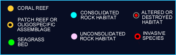
The seagrass beds of this region are marked by the abundance of Thalassia, which is far less abundant along the western shores. Reef flats (e.g Anse Soldat, Calibishie) and sheltered bays (e.g. Hodges Bay) are where they are typically found. To date, invasive species have not been identified in this region. For each of the following areas, colored dots (see key below map) mark the presence of specific habitats baring sessile epibenthic communities. The areas / sites are: 1. Capucin to Carib Point; 2. Carib Point to Blenheim River (work in progress); 3. Blenheim River to Pointe La Soie; 4. Pointe La Soie to Melville River (work in progress). |
|||||
|
|

INDEX | INTRODUCTION |REGIONS | HABITATS | SPECIES | STATUS | CONTRIBUTORS | REPORTS
Institute
for Tropical Marine Ecology ITME Inc., P.O. Box
36, Roseau, Commonwealth of Dominica.
ITME
is a not-for-profit institution for environmental education and research.